Land to the South West of St. Marys Road, Dunsville, Doncaster

- SIZE AVAILABLE
243,936 sq ft
22,662 sq m
- SECTOR
Commercial development for sale
Key features
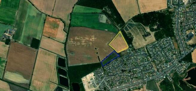
- Gross area of the northern parcel extends to approx 5.60 acres (2.27 hectares)
- Gross area of the southern parcel extends to approx 4.10 acres (1.66 hectares)
- Land located to the northeast of Doncaster City Centre
- Unconditional offers for both sites or separate sites sought by Noon 5th June 24
Description
Situated to the west of St Mary's Road, less than 5.5 miles miles northeast of Doncaster city centre. The parcels also lie 3.2 miles to the north of junction 4 of the M18. the parcels lie 22 miles northeast of Rotherham, 29 miles to the northeast of Sheffield and 42 miles to the southeast of Leeds.
Brochures
Land to the South West of St. Marys Road, Dunsville, Doncaster

NEAREST STATIONS
Distances are straight line measurements from the centre of the postcode- Hatfield & Stainforth Station1.7 miles
- Kirk Sandall Station2.0 miles
- Thorne South Station4.0 miles
About Savills, Leeds
3 Wellington Place, Leeds, LS1 4AP
Notes
Disclaimer - Property reference 40216FA8-741D-4C68-8F20-15573D5F8512. The information displayed about this property comprises a property advertisement. Rightmove.co.uk makes no warranty as to the accuracy or completeness of the advertisement or any linked or associated information, and Rightmove has no control over the content. This property advertisement does not constitute property particulars. The information is provided and maintained by Savills, Leeds. Please contact the selling agent or developer directly to obtain any information which may be available under the terms of The Energy Performance of Buildings (Certificates and Inspections) (England and Wales) Regulations 2007 or the Home Report if in relation to a residential property in Scotland.
Map data ©OpenStreetMap contributors.