
Land At Thrussington, Hoby Road, Thrussington, Leicester, Leicestershire, LE7 4TJ
£0.21 per sq ft
Business rates & charges may apply

- SIZE AVAILABLE
1,982,416 sq ft
184,173 sq m
- SECTOR
Farm land for sale
Key features
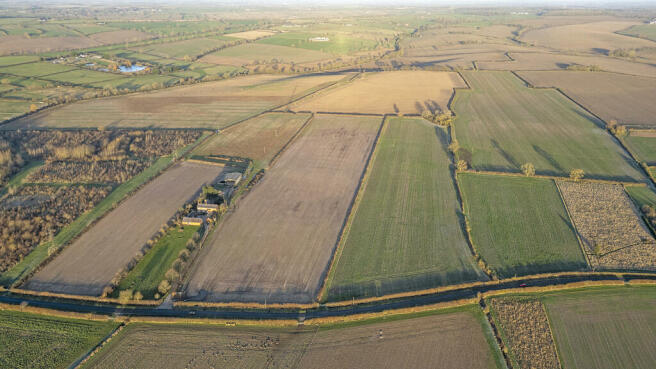
- Two field parcels, approximately 45 Acres of Arable Land.
- Near the Village of Thrussington. Accessed off Hoby Road.
- What3Words LOCATION SEQUENCE -Prune.laying.hinted
Description
Near the Village of Thrussington. Accessed off Hoby Road.
What3Words LOCATION SEQUENCE -Prune.laying.hinted
The property consists of two field parcels extending to approximately 45.51 acres (18.42 hectares) of arable land.
Land at Thrussington.
Detailed Description
The property is bound to the south by Hoby Road, which is the main road connecting the villages of Hoby and Thrussington. The property is accessed directly off the Hoby Road.
The property is classified as Grade 3 and the soil type is generally described as part freely draining, slightly acid, loamy soils and part slightly acid but base-rich loamy and clayey soils.
Cropping Details:
YEAR: FIELD 5765: FIELD 3904:
2021: Spring Oats Spring Wheat
2022: Spring Barley Spring Barley
2023: Oil Seed Spring Oats
2024: Winter Wheat Fallow
The sporting rights, mineral rights and timber rights will be included within the freehold so far as they are owned by the Vendor.
All fixtures and fittings are excluded from the sale unless specifically referred to in these particulars.
All historic entitlements and the delinked payments will be retained by the Vendor and do not form part of the sale.
Location
The property is located approximately 0.6 miles north-east of Thrussington village, 1.1 miles south-west of Hoby village and 10 miles north-east of Leicester City Centre.
These have been prepared as carefully as possible and are based on the Ordnance Survey 1:2500 scale plans. The plans are published for illustrative purposes only and although they are believed to be correct, their accuracy is not guaranteed.
The property is sold subject to and with the help and benefit of all existing rights of way, whether public or private, light, support, drainage, water and electricity supplies and other rights, easements, quasi-easements, and all wayleaves referred to or not in these particulars.
There is a public footpath crossing the property and this is known as H60 "from the north-end of Thrussington village by Wreake House to footpath H50 south of Ragdale".
Charnwood Borough Council, Southfield Road, Loughborough, Leicestershire, LE11 2TN - Tel No: .
Land At Thrussington, Hoby Road, Thrussington, Leicester, Leicestershire, LE7 4TJ

NEAREST STATIONS
Distances are straight line measurements from the centre of the postcode- Sileby Station3.4 miles
- Syston Station3.6 miles
- Barrow upon Soar Station5.0 miles
About Brown & Co, Leicester
5 Geoff Monk Way Birstall Leicester LE4 3BU
Notes
Disclaimer - Property reference 440373FH. The information displayed about this property comprises a property advertisement. Rightmove.co.uk makes no warranty as to the accuracy or completeness of the advertisement or any linked or associated information, and Rightmove has no control over the content. This property advertisement does not constitute property particulars. The information is provided and maintained by Brown & Co, Leicester. Please contact the selling agent or developer directly to obtain any information which may be available under the terms of The Energy Performance of Buildings (Certificates and Inspections) (England and Wales) Regulations 2007 or the Home Report if in relation to a residential property in Scotland.
Map data ©OpenStreetMap contributors.